社会インフラ維持管理Social Infrastructure Management
社会資本(インフラ)の老朽化、労働力不足、激甚化する災害等の社会的な課題に対応し、最新のICT技術の利活用により社会インフラの適切かつ効率的な管理と評価の高度化に貢献します。
Responding to social issues such as aging social infrastructure, labor shortages, and catastrophic disasters, we contribute to the appropriate and efficient management and assessment of social infrastructure through the use of the latest ICT technology.
現場点検支援システム
On-site inspection support system
道路や河川の日常点検、緊急点検等の現場作業を支援するシステムを構築します。
The system is designed to support field operations such as routine and emergency inspections of roads and rivers.
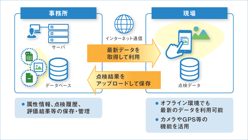
特長
Merits
- サーバ機能と点検用端末のアプリケーション機能の連携により、サーバから必要な情報の取り出しやサーバへの点検結果のアプロード等は手軽に行える
- 市販タブレット端末のカメラやGPS機能の活用により、タブレット1台で写真撮影や位置確認等を効率的に実施
- オフライン地図を具備し、通信の悪い環境でも地図機能を利用可能
- By linking the server function with the application function of the inspection terminal, it is easy to retrieve necessary information from the server and upload the inspection results to the server.
- By using the camera and GPS functions of commercially available tablet terminals, a single tablet can efficiently take photos and check the location.
- Offline maps are available for use in environments with poor communication
3Dモデルの可視化システム
3D Model Visualization System
国土交通省が取り組むi-Constructionにおいては、建設プロセスの各段階における3Dモデルの利活用が求められるため、3次元地理空間での3Dモデルデータの表示・管理・分析等を行える高度なWebシステムの構築を行います。
In i-Construction, which the Ministry of Land, Infrastructure, Transport and Tourism (MLIT) is working on, there is a need to utilize 3D models at every stage of the construction process, and we will build an advanced web system that can display, manage and analyze 3D model data in a 3D geographic space.
特長
Merits
- 3Dモデルの空間形状だけでなく、属性や点検履歴、シミュレーション結果などの情報も検索・表示可能
- 地上だけでなく、地表面以下の管路や基礎などの3次元表示も可能
- 時間軸を加えて時空間4次元の情報可視化により、過去・現在・将来における地形や施設の変化を容易に把握できる
- Webシステムであるため、複数のユーザが同時に利用でき、効率な情報共有と迅速な意思決定に繋がる
- Search and display not only the spatial shape of the 3D model, but also information such as attributes, inspection history and simulation results
- 3D display of pipes and foundations below the ground surface as well as on the ground
- By adding a time axis to the spatio-temporal 4-dimensional information visualization, the changes in topography and facilities in the past, present and future can be easily understood.
- Since it is a web-based system, multiple users can use it simultaneously, leading to efficient information sharing and faster decision-making
※可視化への取り組みについては、こちらもご覧ください。
* For more information on our visualization efforts, please see here.